Simultaneous Localization and Mapping in Dynamic Warehouse Environments
Dynamic warehouse floors, moving workers, shifting pallets, reconfigured racking, break the core assumption that classical SLAM depends on: a map, once built, stays true. Understanding how modern localization systems handle each kind of disturbance separately is the practical grounding an operator needs before putting autonomous mobile robots on the floor. Simultaneous Localization and Mapping in Dynamic Warehouse Environments.
Why warehouses are a worst-case environment for classical SLAM
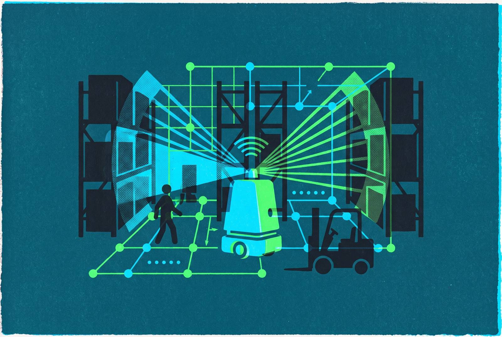
Classical SLAM was built on a bet: the world holds still long enough for a robot to explore it, build a map, and trust that map later. Warehouses break that bet in several ways at once, not just one. Forklifts, pedestrians, and other robots move through the same aisles the robot is trying to map, and their shapes get folded into the feature set meant to represent permanent structure. Shelves get restocked, pallets get moved, and seasonal layouts shift between one shift and the next, so a map that was accurate at noon can be wrong by evening.
Long aisles of uniform racking and blank walls give feature-based algorithms almost nothing to latch onto, and dock doors, shift changes, and skylight cycles push lighting conditions around all day, which destabilizes the visual features these systems depend on. Stacked inventory blocks the line of sight to fixed reference points a robot might otherwise use to correct its position.
Adding multiple robots to the same floor compounds the problem rather than averaging it out. Each robot becomes a moving obstacle for every other robot, and as facilities grow larger, the static, trustworthy features that anchor localization get pushed toward the perimeter, which measurably hurts visual SLAM accuracy, according to the GroundSLAM paper out of the Spatial AI and Robotics Lab. Most visual SLAM algorithms are still built on the static-world assumption, and when they're dropped into a genuinely dynamic scene, tracking failure and overlapping, contradictory map regions aren't edge cases: they're the expected outcome, as the broader literature on the subject documents.
A second-order failure here is the Freezing Robot Problem. Obstacle-avoidance logic tuned conservatively enough to guarantee safety can end up treating every available path as unsafe, and the robot simply stops moving. That's the safety mandate colliding head-on with the operational one, and it's a symptom of the same underlying issue: a system reads a dynamic scene as though it were static, then panics when the mismatch appears in that reading. None of this points to a single broken component. It's a cluster of disturbances hitting the robot at once. No single sensor or algorithm resolves it on its own. The Idealworks/NVIDIA benchmark shows that these conditions (variable lighting, frequent occlusions, semi-dynamic scene changes, and long-duration operation) represent a gap that existing benchmarks, designed for controlled indoor or outdoor driving scenarios, do not adequately characterize.
Warehouse adoption speed of autonomous mobile robots and its impact on SLAM at scale
The AMR market is roughly USD 5.18 billion in 2026, up from USD 4.49 billion the year before, and Mordor Intelligence projects it reaching USD 10.56 billion by 2031, a compound annual growth rate of 15.31% GroundSLAM PUSR. Warehouse and logistics work is the single largest slice of that spend, accounting for 32.94% of AMR market revenue in 2025 Mordor Intelligence. Over 450,000 logistics robots sold worldwide in 2025, against just 75,000 in 2019, a fivefold jump in six years, and the count of robotic warehouses in operation grew from roughly 4,000 in 2019 to an estimated 50,000 by 2025 The Network Installers PUSR.
New deployments now favor AMRs over AGVs by a ratio of roughly 3 to 1, and that ratio says something concrete about what facilities are choosing: flexibility over fixed infrastructure Robotics Center. An AGV runs on magnetic strips or fixed tracks embedded in the floor Robotics Center. An AMR navigates freely using SLAM. That shift isn't a cosmetic upgrade, it moves the entire burden of understanding the environment off physical infrastructure and onto software. Every SLAM failure mode described above now sits directly in the critical path of daily operations.
The economics back this up with real numbers, not projections. One auto parts warehouse renovation using traditional magnetic-strip navigation needed 3,000 meters of embedded strip and 20 days of construction before a single robot could move. Separately, SLAM-driven systems have cut map reconstruction time after a shelf reconfiguration from 4 hours down to 15 minutes, a gain cited in connection with JD.com's Asia No. 1 Intelligent Warehouse. AMRs remove the 60 to 70% of a warehouse worker's shift that goes to walking between picks in goods-to-person workflows Robotics Center PUSR. SLAM reliability isn't just a robot uptime metric anymore, it's a direct lever on throughput Robotics Center PUSR.
LiDAR SLAM vs. visual SLAM in a warehouse
LiDAR earns its reputation for a reason: it measures distance with high precision and keeps working in low light, dust, or fog, conditions that would blind a camera. Slamtec has called laser SLAM the most mature and stable option available for autonomous localization and navigation today, and the track record backs that up. 2D LiDAR SLAM, running on algorithms like Cartographer or GMapping, is the standard choice across indoor mobile robotics, and Cartographer's global optimization in particular handles repetitive indoor layouts well. LIO-SAM and the LOAM family extend that same approach into three dimensions.
The trouble starts in long, repetitive aisles. LiDAR-based particle filter localization, still the dominant approach in production systems, runs into real trouble there: without distinguishing landmarks, the position estimate drifts and the map itself starts to disagree with what's actually on the floor, a limitation the Idealworks and NVIDIA benchmark documents directly. A LiDAR scan is fundamentally a distance measurement, and it can't read the shelf label, the floor marking, or the signage that would tell a human exactly where they are in an otherwise identical row.
Cameras fill that particular gap well. They capture rich photometric and structural detail, and visual data carries semantic cues, text, color, texture, pattern, that inherently disambiguate repetitive spaces in a way a laser range reading cannot. ORB-SLAM3 is feature-based, supports multi-camera rigs, and uses a system called SLAM Atlas to relocalize across multiple stored maps. RTAB-Map is sensor-agnostic and graph-based, with memory management that keeps loop-closure computation bounded even during long-duration operation across large facilities. NVIDIA's cuVSLAM uses CUDA to offload key perception computations to the GPU, achieving minimal CPU utilization, and it runs on NVIDIA Jetson embedded hardware.
Cameras carry their own weaknesses, though, and they're not minor ones. Visual SLAM depends heavily on stable, adequate lighting, and gets unreliable fast in poorly lit or inconsistently lit spaces. Blank walls and uniform flooring starve feature-matching techniques like ORB and SIFT of the keypoints they need to function, and ORB-SLAM3 specifically has been flagged for struggling in exactly these featureless zones. A hybrid stack, cuVSLAM's front-end paired with a custom SLAM back-end, came out ahead on mapping accuracy. Compute cost isn't a side note here either: on embedded AMR hardware, a VSLAM front-end that saturates the CPU risks starving motion planning, obstacle avoidance, and intercommunication processes, and real-time safety guarantees are at stake. LiDAR SLAM weaknesses specific to warehouses.
Multi-sensor fusion as the production standard for warehouse AMRs
Neither sensor wins outright, so fusion, not substitution, has become the default architecture. Multi-sensor fusion combines complementary sensor strengths while mitigating individual limitations: LiDAR precision, visual semantic richness, and IMU motion continuity. Essenn Associates notes that most production AMRs already run this way: LiDAR SLAM fused with wheel odometry and IMU data for localization that doesn't collapse when one sensor has a bad moment. Slamtec expects fusing LiDAR precision with visual richness to become the industry's mainstream approach going forward. Patent filing data from PatSnap covering 2023 through 2026 backs this up structurally: the dominant innovation cluster in indoor localization patents is multi-sensor fusion, spanning LiDAR SLAM, camera-LiDAR combinations, UWB, RFID, and EKF-SLAM, and it underpins nearly every other capability tracked in that dataset.
Fusion sounds simple in concept and is genuinely hard in practice. In testing with Geek+'s M1000R handling robots, fusing sensors lifted dynamic obstacle detection accuracy from 78% to 95% and cut obstacle-avoidance response time down to 200 milliseconds GroundSLAM PUSR. A separate example, an edge computing setup at a Shenzhen new energy battery factory, ran core SLAM computation locally on the robot and uploaded only key pose data to the cloud over MQTT, cutting cloud transmission volume by 70% and stretching autonomous operation during network outages out to 30 minutes PUSR.
None of that solves everything, though. A well-fused sensor stack still has to deal with the fact that something is moving through its field of view right now, and fusion reduces the odds of a sensor failing outright, but it doesn't by itself stop a forklift's outline from getting baked into the static map. That problem needs its own answer. Hardware-level time synchronization is a non-trivial requirement, as nanosecond-level data alignment between LiDAR, RGBD cameras, and IMUs is necessary for coherent fusion; PUSR cites the USR-EG628 industrial computer as an example of hardware meeting this spec.
Three distinct classes of warehouse disturbance and how SLAM approaches handle them
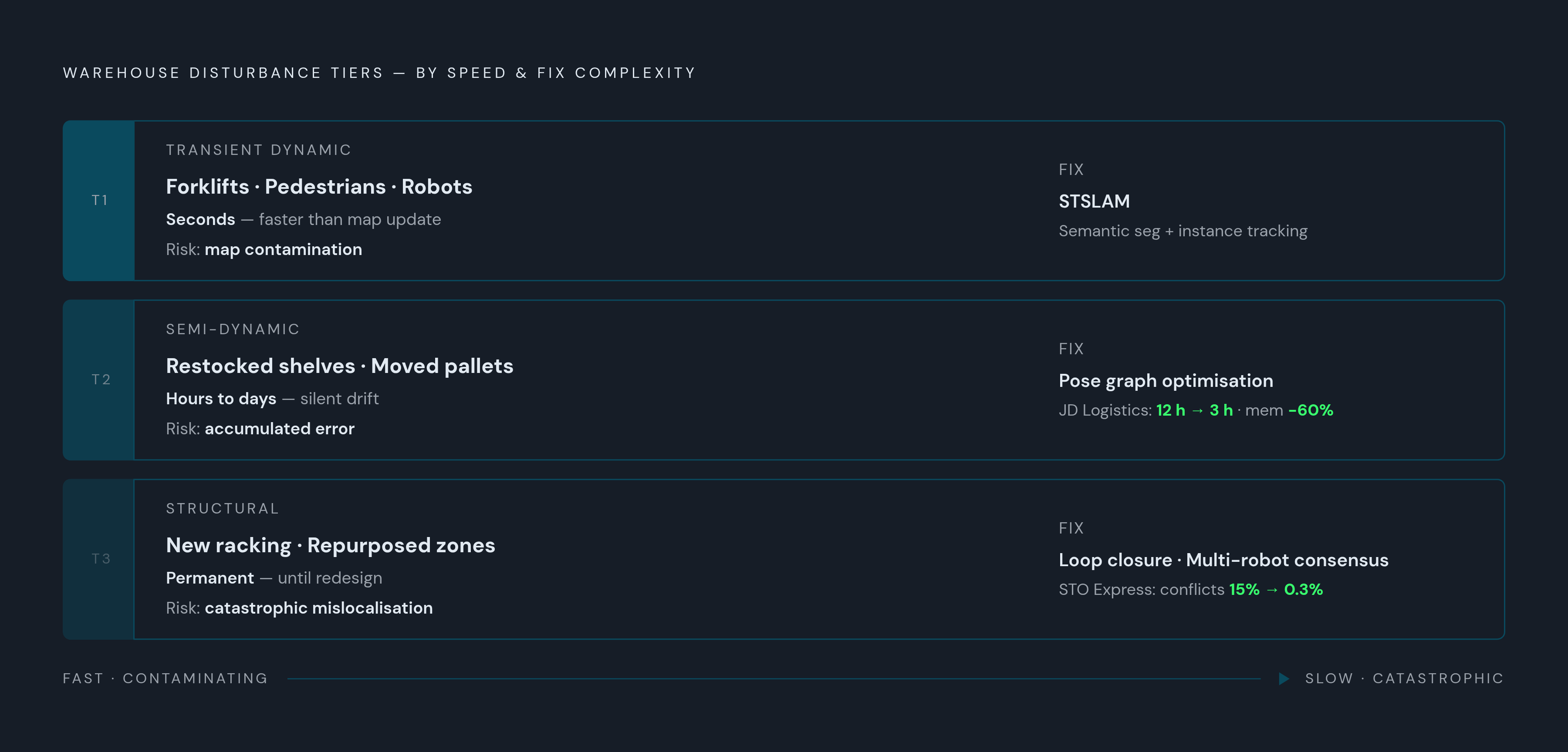
Not every disturbance in a warehouse behaves the same way, and treating them as one undifferentiated "dynamic environment" problem misses the point.
Transient dynamic obstacles, forklifts, pedestrians, other robots, are the fastest-moving category. They appear and vanish faster than a map update cycle can register them properly, and the real danger is that their features get folded into the permanent map, quietly poisoning every localization attempt that comes after. STSLAM, published in Robotics and Autonomous Systems in December 2025, tackles this with semantic segmentation and instance tracking, identifying dynamic objects and excluding them before they ever touch the map GroundSLAM PUSR. It jointly estimates camera pose and instance-level map points, using panoptic projection along with shape, scale, and rigidity constraints inside a factor graph optimization. The paper's central argument is direct: inadequate modeling of dynamic instances is the primary reason SLAM systems fail to track in dynamic scenes, not sensor noise, not compute limits. Separately, reinforcement learning approaches built on DQN, SAC, and MDP formulations are showing up in the patent landscape, training robots to navigate around dynamic obstacles without hand-coded rules. That connects directly back to robots freezing when every available path reads as unsafe: hybrid architectures combining reinforcement learning with the Dynamic Window Approach, patented by Tata Consultancy Services across 2025 and 2026, drop the assumption that training happens offline once and stays valid, which matters enormously in a warehouse that keeps rearranging itself.
Semi-dynamic changes, restocked shelves, moved pallets, temporary obstructions, sit on a slower clock. They persist for hours or days before shifting again, and the danger here isn't contamination, it's staleness: the map goes out of date and the robot has no built-in way to know it. Graph-based SLAM with pose graph optimization handles this by adjusting the whole map globally once an inconsistency turns up, instead of forcing a full remap from scratch. At scale, that means dividing warehouses covering 100,000 square meters into submaps and holding them consistent through pose graph optimization; JD Logistics reported reducing map construction time from 12 hours to 3 hours and decreasing memory usage by 60% using this approach Robotics Center GroundSLAM PUSR. Algorithm-level gains matter too in these repetitive, feature-sparse zones: LeGO-LOAM's ground plane feature extraction pushed positioning accuracy in long corridors from 0.5 meters down to 0.1 meters, and Geek+'s own SLAM algorithm, using IMU and wheel odometer compensation, cut trajectory reconstruction error from 0.3 meters to 0.05 meters at a 2 meter-per-second AGV speed PUSR.
Structural reconfiguration is the hardest category by far: full layout changes, new racking, zones repurposed for something else. Here the old map isn't just outdated, it's actively wrong, and a robot that trusts it will localize confidently to the wrong place. Loop closure has to be sharp enough to notice that a familiar-looking location no longer matches what's stored, and trigger a remap rather than force a bad fix. Multi-robot systems help distribute that burden: distributed consensus algorithms let robots share map updates in real time, and at STO Express's Shanghai hub, this cut the positioning conflict rate among 50 robots operating together from 15% down to 0.3%, while task allocation efficiency improved by 40% The Insight Partners PUSR. Deep learning-based feature extraction adds resilience on the vision side: CNN networks, replacing traditional SIFT/SURF approaches, improved feature matching success rates in low-light environments from 62% up to 89%, and more generalizable features are more resilient to layout changes that remove familiar landmarks.
GroundSLAM's approach: redirecting the camera to avoid the dynamic scene entirely
GroundSLAM, from the Spatial AI and Robotics Lab (Kuan Xu, Zheng Yang, Lihua Xie, and Chen Wang), took a different route entirely when it appeared as an arXiv preprint on April 16, 2025 PUSR. Instead of building better ways to detect and strip out dynamic objects, it points the camera down at the floor and never looks at the dynamic scene. Forklifts, robots, and people walking through the aisle simply never enter the frame, so there's nothing to contaminate the feature map with. That sidesteps semantic segmentation, instance tracking, and dynamic object classification altogether, and the computational load drops accordingly, since the system never has to reason about what's moving and what isn't.
The engineering underneath is built to match that constraint. GroundSLAM runs feature-free visual odometry using a kernel cross-correlator for image-level pose tracking, so it doesn't need corners or keypoints the way ORB or SIFT do. It keeps working on ground textures that are sparse or repetitive, exactly the surfaces that break conventional feature matching. It pairs that with ground-texture-based loop closure and map optimization, plus the ability to reuse a map when the robot returns to a previously mapped area. Output comes as a 3-degree-of-freedom camera pose, two dimensions of translation plus rotation.
The team evaluated the system on what stands as the first ground-texture dataset with precise ground-truth poses, 131,000 images spanning 10 different indoor and outdoor surface types GroundSLAM. GroundSLAM outperformed prior methods across both settings, and a live mapping demo on an AGV running a rectangular loop inside an actual warehouse backed the lab results up in the field. Operators should weigh one real limitation before adopting it, though: the system outputs 2D pose estimates, which suits flat-floor warehouse navigation fine but offers nothing for vertical localization, and it still needs the floor surface itself to carry enough texture variation to track against. Even with that caveat, GroundSLAM handles environments where objects move around by choosing where you point the sensor, not by making the algorithm looking at it smarter.
Sources
- GroundSLAM: A Robust Visual SLAM System for Warehouse Robots Using Ground Textures
- Warehouse Robot Navigation: Optimization Practice of SLAM Algorithm for IoT Controllers
- Industrial cuVSLAM Benchmark & Integration
- STSLAM: Robust visual SLAM in dynamic scenes via image segmentation and instance tracking - ScienceDirect
- thenetworkinstallers.com
- thenetworkinstallers.com
- Autonomous Warehouse Robot Technology Landscape 2026
- essenn.associates